Ski Holidays & AccommodationBOOK

Discover some of Cheeseman’s stunning alpine walks and tramps in the Craigieburn Ranges. From short strolls to multi-day alpine adventures, these tracks immerse you in the raw beauty of the Southern Alps. With both Snowline and Forest lodges available for groups, tramping clubs and friends, hiking enthusiasts can stay at a comfortable base and make the most of their alpine escape.
ACCOMMODATION
 Snowline Lodge (rear) is a comfortable expedition base with expansive views.
Located higher up the mountain on the ski field, is available for exclusive bookings from 1 October to 30 April for groups of up to 67, with 65 in bunk rooms (4 – 6 bunks per room) plus one double bedroom. Summer is BYO and Winter is fully licensed.
 Forest Lodge is nestled at the fringe of the bush.
Located at the bottom of the mountain nestled on the fringe of a native tussock plateau and beech forest. Forest Lodge is a backpacker lodge sleeping up to 38, in dorm-style bunks. BYO food and can be hired exclusively. No minimum group size. You may be sharing with other back packers if you don’t have an exclusive booking. Weekends fill up a long way in advance.
MOST POPULAR
This is a lovely, moderate, scenic track for hiking or biking with the odd rutted out track that might catch your pedal. You can start either end at Texas Flat on the Cheeseman Ski Field road, or up behind Castle Hill Village. It can also be walked on your way to either lodge. It’s walkable from Forest Lodge, but if you’re staying at Snowline Lodge, it requires connecting from Cockayne and or BSC tracks or driving down the hill.
It is usually a one way or out and return track, but it can be extended by a loop around Leith Hill (see map) at the Castle Hill end or a small loop on the new BSC track. If you have multiple vehicles, you can park some at Castle Hill Village and others at Texas Flat Mt Cheeseman, and cross paths.
Starting from Texas Flat, park at the chain fitting sign at the edge of the bush (before the road heads down to Timms Stream). The track zig zags up the hill on the left, starting just a bit further along a tussock track as you’re looking towards the mountain. This knob is called Ernie’s Mistake (because apparently Ernie was going to make a trail up into a valley next to Porters, then realised he’d made a mistake).
Starting at Castle Hill: From the access road to Thomas Bush just west of Castle Hill Village (drive through the village and out the other side), you’ll see the track marked on the right. There are two tracks, and they converge higher up on the spur; the “Thomas Bush” track (steeper) is a downhill track (coming from Texas Flat to Castle Hill), and the Hogs Back is the gentler walking/biking track (lovely gentle gradient with lots of zig zags). The track climbs through beech forest onto the Long Spur ridgeline. After following the ridgeline, the track then descends across the open flats below Long Spur to the beech forest at Long Creek. After going through the beech forest, there is a short climb up the true right of Waterfall Creek. After crossing Waterfall Creek, the track then traverses across to the western side of the Hogs Back ridge before dropping down to Texas Flat (via Ernie’s Mistake, the hill adjacent to Texas Flat). Total distance 7.4 km.
From Snowline Lodge, hike up Hinman Highway (looking up the mountain, the track to the left of the lodge). Head up the cat track as it zig zags left of the Tbar and goes under it. The track continues from above the main Tbar up to the ridge.
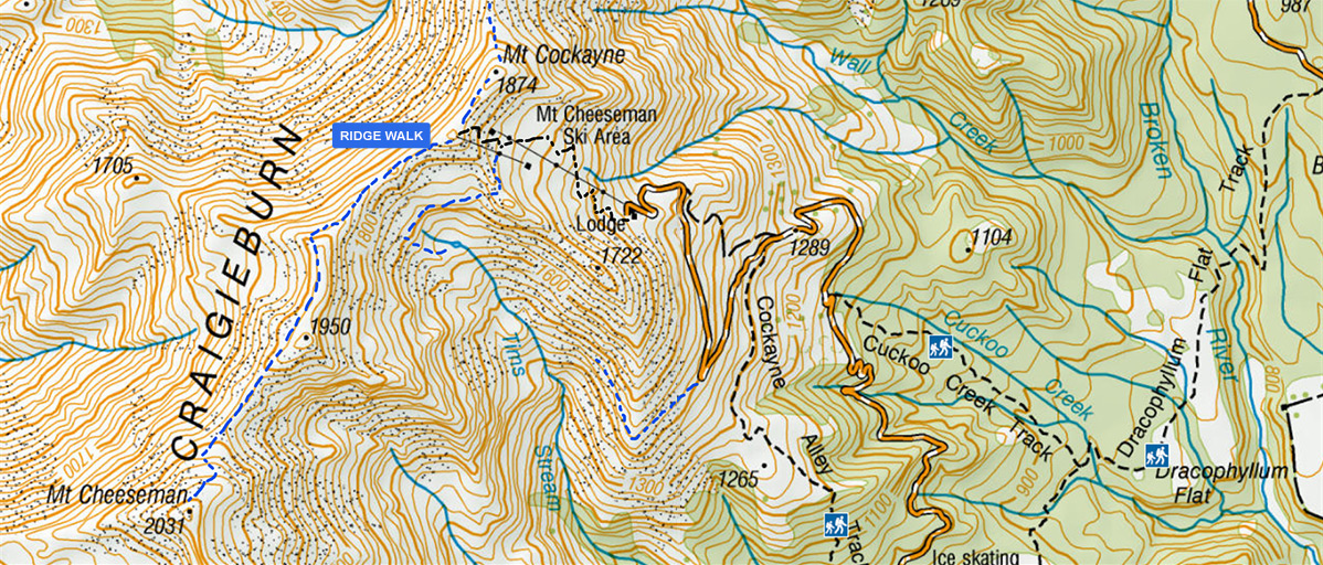

Use the above Ridge Walk, or at top of main (first) Tbar, there is a slightly lower saddle on the left under the Top TBar that ski tourers use to return from Tarn (unformed). From the ridge, drop over the back. Have a swim and come back down to the lodge.


In Summer, once at the ridge, you can walk around the ridge from Tarn to Mt Cheeseman (funnily enough, this peak is not actually on the skifield) and down into Timms Creek. On the other side of Tarn, you’re better to go up and behind the rocky outcrop to North Tarn or Tarn Chutes To get from Timms Creek valley to Snowline, don’t go all the way down. Sidle around at about 1500m. Walk out to Big Bend corner and walk back up to Snowline. Note this is pure scree slope with no path.(Avalanche prone in winter. Dangerous to exit on the scree to Big Bend when snow is on the ground. See more detailed Tarn Basin info and avalanche fall path maps).
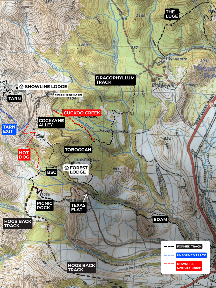
To get to Texas Flat from Timms Creek valley instead of exiting at Big Bend, you can scramble down screes and a few deer tracks (one good one apparently) or there is new downhill mountain bike track Hot Dog (watch out for downhill bikers and move out of the way quickly as it’s been recently build by bikers, and is not a designated walking track. Part way down, Hot Dog connects with either Cockayne Alley or BSC.
Big day. With an early start from Snowline Lodge, hike up to the ridge (1hr), heading right to Mt Cockayne. From there, (unmarked track) go along the top ridge (exposed in windy conditions or bad weather) past Mt Wall (2.5-3h). Drop down into Broken River ski field. Walk down the skifield road until you get to Jacks Pass (1h?).
Dracophyllum track is on the right coming down (can be confusing here as there is a side track to some baches – the track starts nearer the skifield road rather than further along the side road where it leads to the baches). Walk Dracophyllum (estimate 2.5hr?). While in the bush, turn right up into Cuckoo Creek rather than continuing to Texas Flat (Cuckoo Creek estimate 1.25h up? – steep mountainbike downhill track with jumps).
When it exits onto the ski road, turn right to walk uphill. You’ll come to a slightly flattened area on the right, signposted the site of the old Middle Hut (no longer a hut here, just a small car park). You can walk up the road (shallower gradient) or follow up diagonally to the right on the old access tow line to Snowline until it rejoins the main ski field road and walk the last bit on the road (40m?) to get back to Snowline.
*This full trip has not been time-verified. Could be a long day. We are looking for fit trampers to verify how long it takes!

Refer Cockayne Alley below, backwards.
New alternatives as of 2025: Go down Cuckoo Creek, head right at Dracophyllum Flat, go left a little way along Edam, exit at Texas Flat, do the first part of Hogs Back, jump onto BSC (new in 2025) and back up Cockayne Alley. Or try going up to Tarn, down Tarn exit (in summer, safest when there is no snow) to Big Bend, down Hot Dog (listen and move quickly for bikers), across BSC to rejoin and go up Cockayne. Please be friendly to bikers hurtling down Hot Dog as they built this trail for biking, not hiking.
Pretty track through bush before coming out above bushline.
From Forest Lodge, follow the road up to the turn off into Forest Lodge. You can turn downhill down the road and enter the track on the right side of the road. But there is a shortcut where the Forest Lodge Road joins the main skifield road.
The track starts moderately and climbs steadily to become steep. Continue up to exit the bush on the ridge line. 30 – 45 mins.
Continue up ridgeline and follow markers to “Lunch Tree” and the remnants of Old Middle Hut (approx. where it says 1265 on the map). This is where they used to walk up to ski before the road was installed. I have a feeling lunch tree has gone now since I walked this.
You can either go back, or on up from here. To go back, from “Lunch Tree” you can return down and then head east on the spur. You can either take the trail directly down towards Forest Lodge, or keep heading down the spur through beech trees (unmarked part) to come out on Mt Cheeseman road at “P60” (unlabelled), a large corner with a small clearing. 30 mins.
Follow road back to Forest Lodge or take. the short cut down Toboggan Track. 20 – 30 mins.
To continue up, from Lunch tree, the track heads right along under the skifield road towards the old Middle Hut site. This part of the track was a Landrover track built to move Middle Hut from its first location (Middle Hut was later blown off its new site some years later, so there is just a bare patch now). Can be exposed higher up if windy. 20 mins.
From Middle Hut carpark, you can walk part way down the Cheeseman Rd and drop down into Cuckoo Creek Track which connects with Dracophyllum Flat track in 1 hour (this is an advanced grade 4 mountain bike track with some gnarly drop offs for bikers). It’s more of a bike track than a walking track. Though there aren’t many bikers, the steeper gradient and jumps don’t make for relaxing walking on this part. It is still another 45 mins from the Dracophyllum track junction near the bottom (turn right) to get back to Forest Lodge/Texas Flat. There are still a few ups and downs from there for the weary. Take lots of snacks!
Alternatively, an easier walk is to walk back down the road and take the Toboggan track shortcut back to Forest Lodge carpark.
More info: DoC.
Lower entry to Cockayne + Dracophyllum as you come up from crossing Timms Stream Bridge. There is parking just a bit further on the corner on the left.


Dracophyllum is a pretty 5.8km track that links Texas Flat to Broken River Ski Field Road. There is a side track to Forest Lodge part way across Dracophyllum Flat. It is more downhill if you start at Broken River end. 1h50m biking time – estimate 2.75h+ walking. Lots of creek crossings – most have bridges. Watch out for mountain bikers.
From Texas Flat follow the Mt Cheeseman Road until the road is in the open and Forest Lodge is in view. There are a few parks on the sharp left hand corner as you leave the bush. Just back from this, leave the road and follow the track across Forest Lodge Flats Track (now called Dracophyllum Flats). Turn off as the track enters the Bush and drops down towards the stream. Continue and cross Dracophylum Flats and up on to Jacks Pass on the Broken River skifield road. This track can be done both ways but requires a driver at one end.
An easy track on flat terrain. Watch for boggy areas.
Walking from Forest Lodge: Go behind the current ice skating rink (forest side of the rink), join up with Dracophyllum Track. Walk South (right) to Texas Flat across the valley, ford Timms Stream , walking to Forest Lodge on the road.
Or, from Forest Lodge, follow the road up to the turn off into Forest Lodge and back down to where the road is out of the bush. Park (near the corner where there is a small parking area to put chains on – not the Texas flat larger chain fitting area) and follow the track across the flats, turning left towards end of the Forest Lodge Flats/Dracophyllum Flat (no sign) to return around the “old skating pond” (there are two skating ponds. The old one is no longer used and sits beside/below the “new” one closer to Forest Lodge). Sidle behind the skating ponds and you’ll come out just along from and above Forest Lodge.

From Texas Flat, go back down Dracophyllum the first 100m before it drops down into the Terrace. Keep walking downstream along Edam walk back the Cheeseman road. Not ideal if hot as little shade.
From Forest lodge follow the road up to the turn off into Forest Lodge and back down the road to the short bridge at Timm’s Stream, called the Gulch. 15 mins.
The track starts leaving the road at the lower corner of the Timm’s Stream bridge. Follow the well worn path up stream. Within 5 minutes you come to an open space beside the stream that would be ideal for a picnic lunch or an overnight camping spot. Continue on until the track meets a bluff at the stream, 10 mins from road. If you are prepared to get wet feet or are able to cross the stream you can boulder hop for another 5 mins up stream until it becomes too difficult to continue.
This is an easy walk on flat gradient and is very pleasant beside the stream. There’s a canyon a bit further up. You can boulder hop but it gets impassable.
Return time from Forest Lodge approximately 1 hour 10 mins.


From Forest lodge follow the road up to the turn off into Forest Lodge. Turn up the road towards the ski field. Past the water tank turn right down hill onto the old toboggan track. This was used to toboggan on in the old days and was access for the skiers to walk up to the ski lodge. The track comes out in the Forest Lodge car park.
Currently singed. From Broken River campground, take the Sidle 73 from camping spot on the right not far in on the Broken River road, heading in the direction towards Craigieburn ski field. Walk up 1km. Go up Lyndon Saddle. Go along ridge, come down the scree onto Luge-Mistletoe intersection (avoids bikers who do the Luge track).
Park at bridge just after Wilderness Lodge by the riverbed. Be prepared for a little snow and ice by Bealey Spur Hutt. If snow, you can go up and back. Moderate. 6.5 hrs meander inc morning tea and lunch. 17.1km. Climb 958m. Or if warmer time of year, you can make big loop extending that to go through Bruce Saddle, maybe down Mid Hill – needs homework. Second part unmarked.
Park at the end of the Luge Track where it comes on the road. Walk up the road to the Camp Saddle (on Broken River). Up Camp Saddle, morning tea there. Along ridge, down the scree, down to intersection of Luge Miscletoe and Craigieburn edge track, up to Helicopter Hill for lunch then back down to the car. 5.5 hrs include morning tea and lunch. 12.4km. Climb 832m. Moderate.
Cora Lynn Rd 12km 6.5hr Moderate. Meanders up then last bit steep. Follow ridge along. Marked trail on Cass Lagoon track. Unmarked as you get on Mt Bruce.
Short drive Mt Cheeseman west along the highway. Walk through groovy limestone water-grooved rocks in an underground cave. 1 hr. Best done in wetsuits over polypro with head torch to avoid chills. There’s a climb out on steel rungs, and you need to hunch along ledge with overhang. Warning: not to be done if rain is forecast as water can rise and it can flood.
Starting point: Cave Stream Reserve, SH73 between the Broken River bridge and Craigieburn Forest Park entrance. Craigieburn Trails app has good weather info on it.

Go into Hawdon Valley campsite over Mt White bridge. Park there. Up and back. 9.18km. 5.5 hours inc morning tea and lunch. Harder with steep scrambly bits and not all marked track. Climb 850m but over the shorter length makes this one a bit of a grunt.
800m grunt from Porters Pass. Steep inclines, loose rocks. 1-2 hours to the top. A rugged climb with great views. Unmarked but well-worn trail through low scrub and tussock and across gravel screes to Foggy Peak. Potential for snowy tops around winter and Spring (crampons). Steep 4.8km up and back track. Experienced fit trampers only. In good weather, you can carry on from Foggy Peak. Follow the broad ridge. The ridge narrows for the final climb to the trig on the summit of Castle Hill Peak (2-4 hours). Recommend hiking poles.
Potential for low cloud obscuring visibility. Experienced parties can traverse across to the gap and down. to Kowhai River if you have a driver. Permission must be obtained to follow this route. See DoC info.
A shorter and easier stop on your way is to Trig M. After you come over Porters Pass from Springfield, half way down towards Lake Lyndon; there’s a lay-by on the left. Walk up Starvation Gully Track up to the Trig. 3.3km distance 446m climb. 45m-1h to trig and you can go further along. See DoC info
Touristy but spectacular and renowned for spiritual significance. For less touristy option, see also Flock Hill rocks.

Back in the mid to late ’70’s, Anne Gibson took her daughter Mary off on a walk when the work party people didn’t need them. Over the course of several work parties, they walked the trails Anne had used as a young member in the mid 1950’s.
In the 1980’s, Mary re-walked these tracks with her mother and marked the trails with wool and blazes on tree trunks, taking children, from Kirkwood Intermediate, through these tracks on their outdoor education weeks. At the end of 2010, Mary and her brother Bill Gibson headed off to re-mark this old trail. They were thrilled to find it amongst the regrowth and fallen trees. They marked it with red wool and tape.
Mary’s sister Sue indicated that from Forest Lodge, they probably went up Toboggan track and walked left around/over a spur, then hopped across Timms Stream (it was too steep and difficult to get past this stream if you started further down). Mary noted: “For those more intrepid there is a way to climb up a spur to your right as you come out of the bush at the end of the Bush Run track and you find yourself on the best scree running slope I have ever seen. Bill and I had a blast there. I also took the Kirkwood kids here in 1988 and they loved it so much they wanted to back another time and repeat the experience. It is a bit of hike up and then after the run, a hike back to the Bush-run.”
“The log-jams are pretty bad on this trail. With help of a chain saw to clear some of the fallen logs this will be a wonderful walk easily accessible from Forest Lodge. I used to allow 90 minutes return with my classes. We recollected its beauty when taking our children in the early 90’s. It will be a good one to reopen. It takes you through the beautiful fairy dells with sphagnum moss and the longest trailing “old man’s beard” I have ever seen. Quite ethereal.”
As an aside, they did not find a good track to join the Tarn basin with the Bush-run and it was quite “hairy’ in places. Since then, Hot Dog and BSC have been built. If looking for Bush Run, Mary says look up to the gaps in the trees when the going gets confusing, though those “little trees” are probably quite big there now. If you find it, please send a snap of your trail track on Strava/AllTrails etc and pics/notes to marketing-at-mtcheeseman.co.nz.
LOGISTICS & PLANNING
Do you have to rent the whole lodge?
For Snowline outside skifield open dates, yes, but you don’t need to fill it! We host a lot of smaller groups of 25 people. Find out more about venue hire. The Day Lodge makes an awesome Canterbury wedding venue with its adjacent accommodatoin.
For Forest Lodge, no. You can have smaller groups but you may be sharing with other travellers.
How to check availability?
You can check Snowline by Visiting our booking site, scroll to the Venue Hire tab, and type in your desired dates. Available dates are shown in green. For Forest Lodge, enquire via https://www.forestlodge.info/

Whether you’re picturing a weekend with a few friends or a tramping club or school outing, Cheeseman is ready to provide a comfortable base. PS We welcome further info to clarify tracks and info on this page. Email from the Contact Us page, attention marketing.
Book early to secure your preferred date.

